


Archaeology
This branch deal with the preservation and protection of ancient and historical monument sites, neolithical sites, fossil sites and monoliths, etc. other than those declared by or under law made by Parliament to be of National Importance. Preservation and protection of ancient monuments, historical monuments and heritage sites have been taken up under the Eleventh Finance Commission Award. The preservation and protection works are in progress.This branch also does exploration works on potential sites.
The Archaeological sites at Bhaitbari, West Garo Hills District have been excavated and the potential sites and mounds have been protected for posterity. Report on the Exploration/ Survey of some of the sites are:-
Report
Report on the Exploration/ Survey of some of the sites are:-
- The Neolithic Site in the Ganol and Rongram River valley in the West garo Hills
- Pre-Historic Archaeology in the Barapani area and Upper Shillong area of the East Khasi Hills
- Archaeological sites at Bhaitbari, West Garo Hills
- The Syndai Historical and Archaeological Remains
On the Exploration/ Survey of the Neolithic Site in the Ganol and Rongram River valley of the West Garo Hills District conducted during the month of March, 2001
The Ganol-Rongram River Valley in the West Garo Hills District of the State of Meghalaya is situated at about Long. 90°.15' E and Lat. 25°.35' N. The area is triangular in shape with the base towards the east and the apex towards the west. The site covering an area of about 16 square km. The site is bound in the south by the famous Ganol River and by the Selbagre-Rongram River in the North. Both the rivers met at the confluent known as Chibagre in the east.
The site is perhaps one of the biggest Stone Age people habitation/pre-historic site. The stone implements generally are being classified into two classifications i.e., the Paleolithic and the Neolithic or the Old Stone Age and the New Stone Age. The stone implements of the Ganol and Selbagre-Rongram River Valley belong to the latter classification or the Neolithic stone implements. This site of about 16 sq. km. In its spam comprising the areas of the villages of Selbagre, Misimagre, Bibragre, Resangri, Rongram, Ganolgre, Chibragri and pushing further towards the northwest up to Thebrongre.
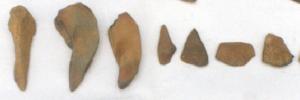 The Exploration carried out during the month of March with effect from 12th-31st, 2001, along with the Anthropology Department of the Guwahati University and the Department of Arts & Culture, Government of Meghalaya under the advice of the ASI Guwahati Circle was of a fruitful success. During the above minute and detailed exploration covering the hill ranges, the streams and the river valleys about 6 (six) important Neolithic sites had been located and 293 stone artifacts of various sizes consisting of axes, scrapers, points, blades, borers, handpick, chopper etc., were collected for the purpose of preserving and exhibiting them in the museums of the state etc., in the interest of the student, researchers, teachers and the general public and the posterity. All the collected stone artifacts are now being kept in the office at Mawlai. Sketch of the site of the site enclosed.
On the joint preliminary exploration on the Pre-Historic Archaeology conducted with the Anthropology Department of the Guwahati University from 8.3.2000 to 14.3.2000 in the Barapani area and Upper Shillong area of the East Khasi Hills District
The Exploration conducted in the Barapani area could not be carried out in a successful manner as we are bound to confine only to a very limited area and could not cover the larger part of the terrain due to thick vegetation or grasses inspite of the fact that some waste product were being discovered during the exploration.
However, in the course of the exploration conducted in the Upper Shillong area, a potential pre-historic site was discovered. From the site about 46 pre-historic stone tools were collected consisting of the following:-
- Axes 7 Numbers
- Points 4 Numbers
- Blades 6 Numbers
- Borers 6 Numbers
- Nose scrapers 14 Numbers
- Side scrapers 9 Numbers
However, the above identification is subjected to further verification. All the above collected stone/ tools implements are being kept in the office of the Arts and Culture, Archaeology Branch at Mawlai Complex of the Department. The site is under the Government Reserve Forest at present.
Bhaitbari Archaeological Site
Geographically, the site is located in the point of the Purana/Old Bhaitbari, a small village in the West Garo Hills District on the southern bank of the River Jingjiram, in a distance of about 3 miles from Phulbari (Garden of flowers) on the way to Tura.
On the basis of various reports and informations, a short exploration was being conducted in collaboration with the ASI (Pre-historic branch) Government of India and the Department of Arts & Culture, Government of Meghalaya during the months of October-November 1991. Encouraged by the findings of this short exploration, exploratory excavation was, accordingly, taken up starting from 29.12.1992. The results achieved in the course of this excavation are not only encouraging but revealing the potentiality of the people deserving to be enlisted in the category of the Archaeological site of National Importance.
During this excavation some very important and valuable findings were exposed. These are as follows:-
- The mud-cum-nurt brick fortification running at least 5 km. in north-south direction in a house-shoe fashion with both ends on the bank of the Jingjiram River. The forttification is of about 15 sq. km. in area andhas been laid taking advantage of the contours of natural hill-lock.
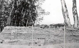 All along the outer side of the fortification the existence of deep moat is observed, whereas on the inner side a rammed murrum pathway which is about 3.30 m in width runs throughout the length of the fMud-cum-nurt brickortification wall. To ascertain the width and stratigraphic position of this mud-cum-brick wall, cuttings were made at two places on the western section. From the discovery of these cuttings, it is evident that in the first phase only a mud tampart having the width of nearly 6 metres was raised. Later on, in order to further strengthen its outer face, a 1.20 m wide of burnt brick wall was raised. During the excavation about 52 courses of these bricks have been exposed. A study of one of these cuttings clearly shows that the burnt brick wall was repaired at least twice and the wall was raised over the foundation of boulders. A stepped entrace on the southern side and a regular gateway on the southern side had also been located.The entire fortified area is covered with thick jungle of bamboos and other trees and the cultivating fields belonging to the villages situating within the fortified area consisting of Rajpur in the south, Wadagogre, Gandhipara and Balojhora in the east, Naya Goan and Belbari in the north
 - The site of a beautifully planned burnt brick temple lying under a mound covered with thick bushes was also unearthed and exposed. In course of excavating the debri of this temple, about 28 terracotts tiles depicting the figure of gods and goddess like, Ganesh, Parvati, Kubera, Yaksha and dancing figure were discovered from within and around the outer face of the wall at the base. However, amongst the four figures that of the four-armed, Ganesh is found to predominates.
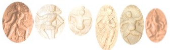 The place of their discovery and the position in wich they were found indicates that the outer face of the wall at the base was decorated with these terracotta tiles. These tiles were fixed on the wall with the help of one or two holds luted on the back of the tiles.The temple is found to compose of three components, the Garbagrihs, the Anterala and the MandapaFigures of Gods and Goddessor the Entrance, the prayer hall and the sanctum sanctorum. The structure is of simple ministure and facing east. The maximum length of the temple east-west including the retaining wall behind the garbhagrihs is 11 metres long.This structure is found to have been built on a Panch-Ratna plan with several effects. The foundation consists of brick bats, whereas the upper on the basis of analithical conclusion, is believed to have consisted of wooden posts, split bamboo mat wallings and thatch-roofing.Further, both the garbhagrihs and the mandapa are square in plan. The garbhagrihs is 4.40 x 4.40 m, whereas the mandapa is 2.50 x 2.50 m. The antarals is '90 m in width. Except for the south-eastern corner of the temple which had been badly damaged due to growth of a jackfruit tree, the rest of the plan of the temple is almost in tack and at least 13 course of bricks are percievable
 - The third and impressive discovery during the excavation was the discovery and exposure of the site of an Octagonal TemShiva Lingaple with eight miniature octagons, each having a Shiva Lings.
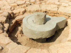 The structure is of a more magnificient architecture, having eight square sub-sidiary shrines radiating from the eight arms of the main octagon. This perhaps one of the unique discoveries during the excavation.The total plan of the temple is 13 m in width and .90 m in height. Like in the case of the earlier stated temple. This Octagonal structure of Shiva Temple also seems to have been built on the same pattern through different in designs and plans. That is, the base consists of the burnt brick bats, whereas, the upper structure is percieved to have been built with wooden posts, split bamboo mat wallings and thatch-roofing and facing in the same direction as the earlier.
 - The fourth, the most unexpected and thrilling discovery during the said excavation was the discover of the site of a structure associated with Buddhism and which is commonly known as "STUPA".On further process of excavation, this STUPA is found to belong to a category of stupa which is structurally termed as 'Mud-stuupa'. This ancient Buddhist remain is situated near the bank of the river Jingjiram very close to the Phulbari-Tura road before reaching Rajpur.In course of the excavation, the outer face of it is found to have been lined with courses of burnt bricks laid on the semi-circular mud structure in the form of boxes, the inside of which were filled up with brick bats. A footstep from the base to the top is also discovered on the southern face of this tupa.This stupa is 5.75 m high and has the diameter of 30 m at the base. This stupa, so to say is the first ever disclosed Stupa in Meghalaya.All the above structure are located within the fortified area. Exploration of the fortified area further shows to contain extensive ruins, such as brick structure, a number of ancient tanks of various sizes, Shiva lingas, broken potteries etc.However, nothing is definitely known at present about the history of the site including the era it flourished. But on the basis of the deities depicted onthe terracotta tiles and thei stylistic taste and the existence of the stupa, scholars somehow have arrived that the period of the flourish of this ancient fortified city may be contemparaneous to the reign of Harsha Vardhana, i.e., to the first half of the 7th Centry A.D.Again from the existence of ancient tanks of various sizes as stated above, this township suggests to be an important temple townsip. However, all that s said is only a question of guess-work. Therefore, the sites still stand as a challenge for those historians and scholars who have the will and courage to dig out its historic truth for the knowledge of the present and the benefit of the future
The Syndai Historical and Archaeological Remains
Syndai is a little village situated on the southern slopes of the Jaintia Hills District over- looking the vast plains of Bangladesh at about 60 km or so from Jowai-Umlarem-Muktapur road. Syndai is one of the most beautiful and important places of interest in the State of Meghalaya. The village and its surroundings has a uniqueness of its own. It is a place of varied interest ranging from its folklores, stupendous waterfalls, natural caves, flora and fauna, spots of scenic beauty as well as site of historical and archaeological remains which can be still seen and observed in and around the area of the Rupasor stream situated at about 1 km. south of the village. Some of these important historical and archaeological remains of Syndai may be seen as below:
- The Rupasor bathing ghat (Ka Mahadei Swimming Pool)
This is a beautiful rectangular swimming pool of about 10.00 m in length, 7.10 m breadth and 1.50 m in depth hewn out of the rock, which forms part of the bed of the Rupasor stream. The pool is forcing in the northwest direction. Tractition states that the pool was created by Luh Laskor Lamare under the direction of the Jaintia king for the purpose of royal bathing. Equidistant from both the corners in the north-end of the pool there is a replica of an elephant carved out of the same rock to serve as a platform for the bathing royals to sit upon. The water was drawn into the pool from the nearby crystal clear stream and was so directed by means of a canal to look as if that elephant is feeding the water into the pool from its trunk. In the south-end of the pool there is a flight of steps hewn out of the same mass of rock leading to the bottom of the pool. At the distance of about 20.00 m to the west of the pool. There are two huge rocks bearing the designs of the Sun with the size of about 3.00 mm and the Moon with the size of 1.30 mm in diameter respectively. The finding of the figures of the Sun and the Moon together in a place expresses the symbol of what is known as fertility cult, as the Moon symbolises the male and the Sun stands for the female. - The ruin royal hill resort
Towards the west just at a distance of about 100.00 m. from the Mahadei swimming Pool by the side of the Rupasor stream in the east and just below the present P.W.D. bridge, there is the site of the ruin structure which is stated to be the site of the Ruin Royal Hill Resort. However, most of the ruins and the debris of the said ruin structure were removed away and used as construction materials during the construction of the Syndai Muktapur road in the recent years. - The Rupasor Megalithic bridge
Just at about a stone-throw distance from the site of the Ruin Royal Hill Resort and below the present P.W.D. bridge an ancient delapidating bridge make of stone slabs over the Rupasor stream is being seen. The purpose for which the bridge was constructed was for connecting the kingdom highway between Jaintiapur the principal capital of the kingdom and Nartiang the Summer capital. - An ancient Mahadei temple
Towards the north and at about 200.00 m. from the site of the ruined royal hill resort by the side of the Muktapur Syndai traditional footpath just before arriving the famous Syndai cave there stands the dilapidated small Mahadei Temple of 6.20 X 7.40 m. made of burnt bricks. The Temple is non-living and a big wild tree is growing on the roof. The purpose for which the Temple was built is stated to be for the royal worship during their stay at Syndai. - Ganesh rock carving
Just about 10.0 m or so below the delapidating Mahadei Temple on the left side of the Muktapur-Syndai traditional footpath there is a beautiful and finely cut figure of the Hindu God known as Ganesh measuring 1.70 m X 1.50 m in size. The figure is so minutely and beautifully carved out on the surface of a rock reflecting the craftmanship of its maker prevailing then.
Besides the above mentioned important historical and archaeological remains, still many more remnants of the past are being found scattered here and there in the area which in all indicates that with the founding of Jaintiapur ( a village now in Bangladesh) as the principle capital of the Jaintia kingdom and Nartiang as the Summer capital sometimes during the 2nd or 3rd of the 16th century A.D. Syndai had replaced the importance of Borghat and became a very important Hill Resort of the Jaintia Royals.